Wednesday, February 25, 2009

I Wish I Was Still In Arizona

I have been busy lately going through my vacation photos of my recent trip to Arizona and California. I still have more to share with you, but it takes time to sort through them and then post to Blogger.

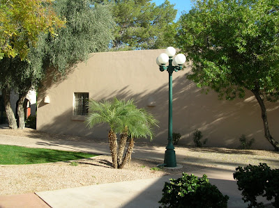
The pictures in today's post look like pictures I would have taken in December. Nope, these pictures were taken this afternoon! Here we are back in the middle of the cold, wintry, snowy weather.

I am going to go back to looking through those vacation photos and dreaming of the warm sunny skies that I recently experienced in Arizona.


Sunday, February 22, 2009

Vacation - Part 9


The first 8 pictures in this post are pictures of the grounds around our hotel in Mesa. We stayed in Mesa for 7 nights at the Best Western Dobson Ranch Inn. http://www.dobsonranchinn.com/
I couldn't resist going for a walk through the neighbourhood near our hotel. I love the simplicity of the landscaping in some of the yards I saw. If I lived here, I would definitely have one of these Saguaro cacti in my yard!

Citrus trees in back yards were very common.


The history of Mesa dates back at least two thousand years to the arrival of the Hohokam people. The Hohokam, built the original canal system that still exists in the Mesa area today. The canals were the largest and most sophisticated in the prehistoric New World. By A.D.1100 water could be delivered to an area over 110,000 acres, transforming the Sonoran Desert into an agricultural oasis. By A.D.1450, the Hohokam had constructed hundreds of miles of canals.
The expanses of green lawns and numerous golf courses in Arizona's cities require tremendous amounts of water to maintain them. Much of the water that now flows through the many canals that criss-cross the Phoenix metropolitan area today, goes towards urban uses. Canals also carry water to municipal treatment plants for distribution as drinking water. This is a photo of one of the many sections of the present day canals that delivers water to all parts of Mesa and surrounding areas.


Vacation - Part 8


The first 8 pictures show here are the scenery we saw as we headed out of Sedona towards Mesa.

The next stop was Montezuma Castle National Monument. http://www.nps.gov/moca/
It is not a castle and the Aztec emperor Moctezuma II was never here; the castle was abandoned at least a century before he was born. The 20 room, 5-storey structure was built into a recess in a white limestone cliff 100 ft above the floodplain. Montezuma Castle was part of a large extended community of Sinagua Indians who farmed in the area from 1100 AD to 1400 AD. When the Castle was first discovered by early explorers, the ruins were thought to be Aztec in origin, hence the name bestowed upon them.


There is a large grove of trees with white bark along the river bank below the ruins of Montezuma Castle. These trees are Arizona Sycamore.

After walking through the park around Montezuma Castle, we sat and relaxed in the shade. This is my Mom and Dad.

And a picture of my Dad and myself under the Sycamore tree.

As we neared Mesa, the Saguaro cactus started to appear. The Saguaro is everywhere, appearing like weeds on the side of the road.


When we stopped for our afternoon coffee break, I noticed this large Prickly Pear cactus.

The fruit of the Prickly Pear Cactus appears as these red "bulb" like growths on the the flat pads of the cactus. This fruit can be sued to made candies and jelly. The fruit is full of tiny seeds which can be chewed and eaten whole or spit out. The fruit can also be made into ice cream. The fruit is peeled and then mashed. The red seeds are left and not strained out. The mashed fruit and seed mixture is then added to milk to make ice cream - no sugar needs to be added. Later in our trip we had the pleasure of trying some Prickly Pear ice cream.

Our final destination on day 5 was Mesa. Mesa would be home for the next 7 nights.

Vacation - Part 7

After travelling through the Oak Creek Canyon, we emerged at Sedona. Sedona is a city of just over 10,000 people located approximately 120 miles from Phoenix.

Sedona is in the center of Arizona's Red Rock Country and the gorgeous red sandstone mountains/formations are evident no matter where you are in Sedona.


There are lots of sculptures on the main street in Sedona. I loved these colourful pigs.

This horse was lifelike.

The girl in the dress is not real--she is part of the sculpture.

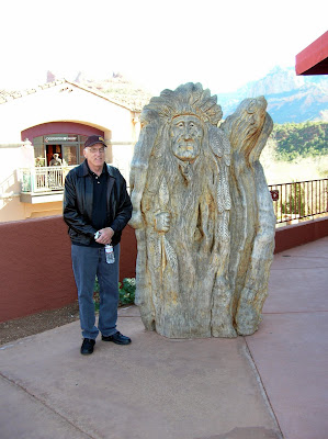
Some of the artwork was wood and not metal. This is my Dad standing next to this wooden carving. (The carving was made from wood, not my Dad! LOL)

When my Mom and I saw the pink Jeeps, we had to take pictures for my daughter who is a Jeep fan.

The Pink Jeeps belong to a tour company. I am sure that the pink Jeeps travelling on the red rocks is quite the sight!

Vacation - Part 6


These first three photos are of our overnight accommodations in Flagstaff: The Hampton Inn.

We started out on the morning of day 5 from Flagstaff and headed south to State Rt. 89A to Oak Creek Canyon.

Route 89A descends a series of switch backs through a scenic smaller cousin to the Grand Canyon. After traversing the hairpin turns of the north end of the canyon we traveled along the bottom of the canyon for 13 km before arriving at Sedona.

Oak Creek Canyon is dense scenic forests.

This photo was taken at Indian Gardens, 4 miles north of Sedona.


At Indian Gardens the scenery in Oak Creek Canyon starts to change from dense forest to the red rock that has made Sedona famous.


These are my parents in front of one of the sculptures in front of a trading post in Indian Gardens.

One of the shops at this location was Garland's Indian Jewelery. The jewelery was magnificent. We could not take photos of the inside of the shop so I have no pictures to show you. However, I encourage you to take a look at their website and browse the many magnificent pieces of jewelery that they have to offer: http://www.garlandsjewelry.com/